Walks in Picos de Europa
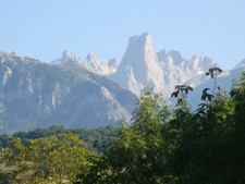 The Picos de Europa, some 70 kilometers west of Santander, are part of the Cantabrian Mountain range running parallel to Spain’s northern coast. The Picos are divided into three spectacular massif regions – The Cornion in the west, Los Urreles in the center and the Andara in the east. They are separated from each other by precipitous canyons carved out by fast running rivers over thousands of years. The limestone peaks rise to a height of over 2600 metres.
The scenery is simply amazing. Everywhere are forest covered jagged peaks. The type of vegetation depends upon which side of the Picos one is. The northern face is very moist, with considerable rainfall caused by the moist air from the sea rising. The southern side by contrast is much more sheltered and dry. Thus on the north side we find beech, oak, ash and chestnut whereas on the southern side we are hiking in pine, Holm and cork oak and Mediterranean type undergrowth. Waterfalls and rushing streams add to the sheer beauty of the place.
There is a wide range of wildlife. In the skies we may see Griffon Vultures, eagles and many other birds of prey. On the ground mountain goats, deer and wild pig side by side with the cattle that form a major part of the local economy in charming pastoral scenery.
As with all mountain terrains, the weather can and does change quickly and it is always wise to be well prepared for wet and cold conditions even if you started out in sunshine. Only take on walks in the Picos that you are confident you can deal with if conditions change. There are two good weather websites. The one recommended by the Picos de Europa authorities is the Spanish Government website. On the map that comes up click on the outline of the Picos. This will give a text forecast for the next 24 hours and will cover conditions at various altitudes. It is in Spanish but is easily understood. It is available as an app. The other is www.meteoblue.com. Key in the nearest town to where you plan to walk. Main gateway towns on the edges of the Picos are Cangas de Onis, Panes and Potes but the site will respond to other smaller towns with the Picos.
These towns, as well as providing the full range of facilities to be expected, also contain Natural Park offices where comprehensive information on the Picos is available. The geology of the region is such that road distances to the start of hikes can be quite lengthy often involving spectacular canyon drives! Probably mid May to mid October are the best times for hiking in the Picos. Outside of these times there is a very real likelihood of snow, certainly above 1000 metres. For lovers of hiking in mountainous terrain, there can be few places in Europe to equal the Picos de Europa.
If you are travelling towards Potes and the southern side of the Picos, you will pass the new Visitors' Centre at Sotama just a few kilometres short of Potes. This rather odd looking huge brown rectangular building houses an excellent display of information that will give a thorough insight into all aspects of the Picos. There is also a continuous audio-visual without commentary which is quite stunning. It is open every day between 0900 and 1800 and is free.
Jim Arymar