Walking in El Hierro
The Island
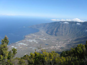
 El Hierro, like all the Canaries, is a volcanic island. It is a steep island; the highest point is just over 5000 feet but less than three miles from both the north and south coasts. There are a few villages (La Caleta and Restinga, for example) and one town (Frontera) at or close to sea level but the rest of the settlements are between 2000 and 3500 feet above sea level.
The steepness of the island and its position in the Atlantic mean that moist air blown in from the sea is forced up over the island where it condenses into mist. This can be a very localised phenomenon – one place can be in bright sun and somewhere half a mile away can be in mist. The mist moves rapidly and unpredictably, varying with the wind direction and time of day. El Hierro felt colder than the other Canaries – the cottage we rented had, and needed (in January), a wood burner and a de-humidifier. It would be warmer at sea level, of course.
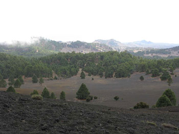
Because of this moisture, the island is very green – except for the areas of picon and lava which do not support plant life. The central plateau has areas with fields and drystone walls that look remarkably like the Yorkshire Dales. But there are areas of cultivation, groves of almond trees, canarian pine forests and laurel forests. The highest peaks are bare gravel.
 Tourism has not, really, reached El Hierro. Among the good things are almost empty (but mostly good) roads, a clean environment and almost total peace. No aircraft routes overfly the island and there is no industry apart from some quarries. But there seems a dearth of restaurants and bars with few offering terraces or outdoor areas. The cuisine is almost exclusively Canarian/Spanish. There is a reasonable supermarket on the southern edge of the town of Valverde but most of the villages just have a small grocery shop which keeps short hours. There is a tourist office in Valverde which we didn't actually find during our visit, although we looked!
There are several bus routes on the island but they seem designed for the locals and their schoolchildren and there are, at most, four buses a day on any route, only one of which is after lunchtime.
 One of the main routes and several of the minor ones are on unsurfaced roads. Check the insurance with your hire car but you will, almost certainly, not be covered on these roads.
The central plateau has masses of wild flowers but there are cacti and other succulents on the rocky areas. We saw many butterflies and birds, too, including a lot of kestrels.
The cliffs surrounding the island have a number of viewpoints (‘miradors’) which have spectacular views. Those of Las Playas, Jinama and Pena are not to be missed but several paths follow the cliff edges and have great views throughout their length. You don’t have to get that close to the edge so vertigo sufferers need not avoid the island!
From many places – on a clear day – you can see other islands: Tenerife, La Gomera and La Palma.
The Walking
 Don’t come to El Hierro unless you are prepared to climb at least a couple of thousand feet in a day’s walking. Even the central plateau slopes and it is surrounded by very steep cliffs.
There is a good network of waymarked walks. The GR131 runs from one end of the island to the other and there are about a dozen PR routes that criss-cross the island. All of these have conventional marks – red and white for the GR131, yellow and white for the PRs - with good signposts at most of the junctions.
When we were planning walks, we used a program that modelled the terrain to give the ascents and descents and many walks that looked easy on the map turned out to need 4000+ feet of climbing. Many of the waymarked paths – if followed end-to-end -are like this. But our knees and lungs are not really up to this nowadays and we reckoned that most of the best views and landscapes could be enjoyed without these efforts. So, with a couple of exceptions, we planned circular routes that linked up sections of the GR and PRs and these are the ones which we have published.
Many paths are old, stone-laid, donkey trails so we recommend good boots.
Despite the good network of paths, they are almost empty. On most days we met nobody at all.
How to get there
There are no international flights to El Hierro airport. So to get to El Hierro, you need to fly to another of the islands and then get an internal flight or a ferry. The nearest big island is Tenerife and that is served from a large number of European cities. Most of the charter and low-cost flights land at Tenerife South whereas most of the flights to El Hierro fly from Tenerife North which is an hour or so away by road.
There are ferry services from Los Cristianos : Fred Olsen fast catamarans run 4 days a week and take two hours, Armas ships run three days a week and take four hours.
 If you plan to drive a hire car on El Hierro then you can hire cars at El Hierro airport (Cicar and Bamir are both there). It is said to be possible to hire a car at the port to meet a ferry but there are no offices in evidence at the port. An alternative, that we used, is to hire a car at Tenerife South and take it on the Fred Olsen catamaran. This saves the need to organise transfers from airport to port and hotel in Tenerife and, if you are self-catering, it allows you to stock up on supplies in Tenerife where there are bigger and cheaper supermarkets. Only two of the hire car companies in Tenerife allow cars to be taken off Tenerife : GoldCar is one of these but they charge a €8 per day (capped at €60) premium; Cicar also allow cars to be taken off Tenerife. The cost of a car on the ferry in addition to passengers is about €40 return. We (two OAPs and a car) paid €200 total return for the catamaran.
Two things to remember about the Fred Olsen catamarans. Even if you have booked and paid on-line you still need to convert this to physical tickets at the office. And if you are taking luggage without a car, bags can be loaded into a sort of ‘wagon train’ with lockers costing €1 each. This is parked on the quayside and loaded onto the ferry just before it sails – but make sure you use the right one or your bags will go to La Gomera or La Palma!
Whichever route you choose, you are likely to need a hotel night in Tenerife in one or both directions.
Where to stay
 Where you stay depends on the walking you want to do. The walks we planned were all circular and, with two exception, followed routes high on the island. To avoid a long drive to reach each walk, that means staying in one of the towns or villages on the central plateau. Hotels in Valverde, El Pinar and, possibly, Moconal meet this criterion, as do a number of self-catering properties in these areas as well as San Andres and Isora.
The Parador is smart but very much ‘out on a limb’. The nearest walks both start with 3500’ climbs or there is a long drive through the port to get anywhere. But it could be nice for a day or two of lazing before or after a walking holiday and there is free wi-fi in the lounge and terrace!Self catering properties are flexible about booking dates and the going rate for one sleeping four is around €60 per night – but you may be able to haggle.
Internet links
Official tourism website
www.elhierro.travel
Bus timetables
www.elhierro.es/files/Turismo/Transportes/Horarios%20Guaguas.pdf
General information about walking on the island
www.tourmac.info/in/canarias/elhierro.php
www.viajeacanarias.es/index.php/el-hierro.html
Waymarked walking routes
www.tourmac.info/imagenes/mapa_hierro_pdf.pdf
Ferries
www.fredolsen.es/en-us/
www.navieraarmas.com/en/horarios_en#boton_resultado_resultado
Flights to El Hierro
www.bintercanarias.com/
Properties
elhierro.granturalcanarias.com/
Hotels
www.parador.es/es/parador-de-el-hierro
Search Google for Boomerang Hotel Valverde and Hotel Villa El Mocanal
or try www.travelrepublic.co.uk/
Download maps
centrodedescargas.cnig.es/CentroDescargas/buscadorCatalogo.do
and choose MTN50 or MTN25 sheet 1028